
inspiration
|
Our project was inspired in part by this clip from “The West Wing”, a small section of which appears in our final video.
(2012). Why are we changing maps? (from The West Wing) - YouTube. Retrieved July 2, 2014, from http://www.youtube.com/watch?v=eLqC3FNNOaI. |
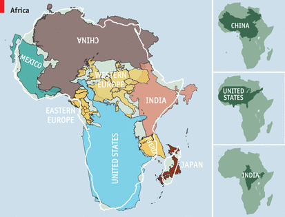
Click on the image above to read a blog post from The Economist that highlights the misunderstandings about Africa we thought we would find. Just look at how massive the continent is! Doesn't that blow your mind?
(2010). Cartography: The true true size of Africa | The Economist. Retrieved July 2, 2014, from http://www.economist.com/blogs/dailychart/2010/11/cartography. |
Annotated bibliography
|
Clarification of Selected Misconceptions in Physical Geography
This article, while originally published in 1992, nonetheless presents a great view into common misconceptions in physical geography. While most of these misconceptions do not relate to our experiment (air weight, oceanic, and atmospheric misconceptions, for example), directly relevant to our experiment is the concise explanation of “Locational Misconceptions”: "...people tend to simplify their cognitive maps by aligning them with one of the four cardinal directions. Hence, the United States, minus Alaska, is perceived as being due west of Europe rather than somewhat to the south as well.” Nelson, B. D., Aron, R. H., & Francek, M. A. (1992). Clarification of selected misconceptions in physical geography. Journal of Geography, 91(2), 76-80. |
A S(t)imulating Study of Map Projections: An Exploration Integrating Mathematics and Social Studies
This article looks closely at just what a map projections is. What does each projection preserve and what does it distort? What is it good for and what are the drawbacks? The article discusses the Mercator and Robinson projections in some detail, then provides a sample lesson to uncover and address misconceptions about map projections that examines the amount of water covering the earth. Wilkins, J. L., & Hicks, D. (2001). AS (t) imulating Study of Map Projections: An Exploration Integrating Mathematics and Social Studies. Mathematics Teacher, 94(8), 660-71. |
Projections and propaganda
This book published online by Learn NC is a very readable overview of mapping skills and thinking. We found Chapter 9 to be the most helpful as it compares the Mercator directly against the Peters projection. Walbert explains why, from a cartographic perspective, these maps produce distortions. He also places both of them in their historical and cultural context, which helps us understand why each map is designed the way it is. (2010). Projections and propaganda - Map skills and ... - Learn NC. Retrieved July 2, 2014, from http://www.learnnc.org/lp/editions/mapping/6434. |
Gestalt Theory
Here's a brief definition of this key term which helps to explain one of the misunderstandings we discovered. People didn't recognize the shapes of the continents on their own separated from the image that they were used to, a world map.
(2012). Online Journal - Society for Gestalt Theory and its ... Retrieved July 2, 2014, from http://www.gestalttheory.net/cms/index.php?page=onlinejournal.
Video Citations:
(2007). Arno Peters: Radical Map, Remarkable Man ... - YouTube. Retrieved July 2, 2014, from http://www.youtube.com/watch?v=osQN7aSQV9w.
(2013). The real map of the world ( Peters Projection) - YouTube. Retrieved July 2, 2014, from http://www.youtube.com/watch?v=2MLiFk3GUI8.
(2011). Map projections of the Earth - YouTube. Retrieved July 2, 2014, from http://www.youtube.com/watch?v=X4wgFSHZXBg.
Images Used:
(2011). File:Gall–Peters projection SW.jpg - Wikipedia, the free ... Retrieved July 2, 2014, from http://en.wikipedia.org/wiki/File:Gall%E2%80%93Peters_projection_SW.jpg.
(2011). File:Mercator_projection_SW.jpg - Wikipedia, the free ... Retrieved July 2, 2014, from http://upload.wikimedia.org/wikipedia/commons/f/f4/Mercator_projection_SW.jpg
